Information About Shelby Farms
Road Plan Alternative F
On Monday, September 24, 2001, I attended the public meeting on the road plan known as alternative F. The purpose of the meeting was to announce this is the road plan our local leaders have chosen as the best compromise between community traffic needs and preservation of Shelby Farms. This plan is of interest to mountain bikers because it intersects the Tour-de-Wolf Trail in the gate 12 area.
This proposed plan is for a six lane road, expandable to eight lanes, going from existing Walnut Grove on the west northeast to the north edge of the park. Then proceeding along the north edge of the park to the gate 12 area where the road cuts southeast to the existing Walnut Grove - Germantown Road interchange. A map is included on this page.
The meeting agenda was:
1 Welcome and Moment of Silence for the WTC tragedy
2 Explanation of Meeting Purpose
Information Meeting
Ground Rules
Formal Announcement Concerning "Walnut Grove Relocation"
3 Description of Meeting Format
4 Introduction of Subject Matter Experts
5 First Session (45 Minutes) to view maps of all road planes and ask questions. Visitors developed written questions for subject experts.
6 Break for submission of written questions
7 Second Session for discussion of written questions.
8 Closing statements.
Included below are scans of the documents handed out at the meeting and an updated map of the plan. I also have notes of the question and answer session. I will get these transcribed and on the web site as soon as possible. The map will also be updated when better information is available.
Comments about this road plan should be sent to:
Theodore (Ted) C. Fox III
Director, Public Works Division
Suite 801
160 N. Main Street
Memphis, TN 38103
Office (901) 545-4266
Fax (901) 545-3796
E-mail
fox-t@co.shelby.tn.us
Shelby County Tennessee
Jim Rout, Mayor
For Immediate Release September 17, 2001
Contact Communications Manager: Kim Brukardt, 545-4588
Walnut Grove Relocation Project (Alternative F) Meeting Set for Sept. 24
MEMPHIS, TENN. (SEPTEMBER 17, 200 1)...A public meeting will be held at the AGRICENTER auditorium on September 24 from 6 p.m. - 8 p.m. to present the findings of the Tennessee Department of Transportation (TDOT) Environmental Technical Report concerning Alternatives A through E for the Kirby-Whitten Road alignment in the Shelby Farms area.
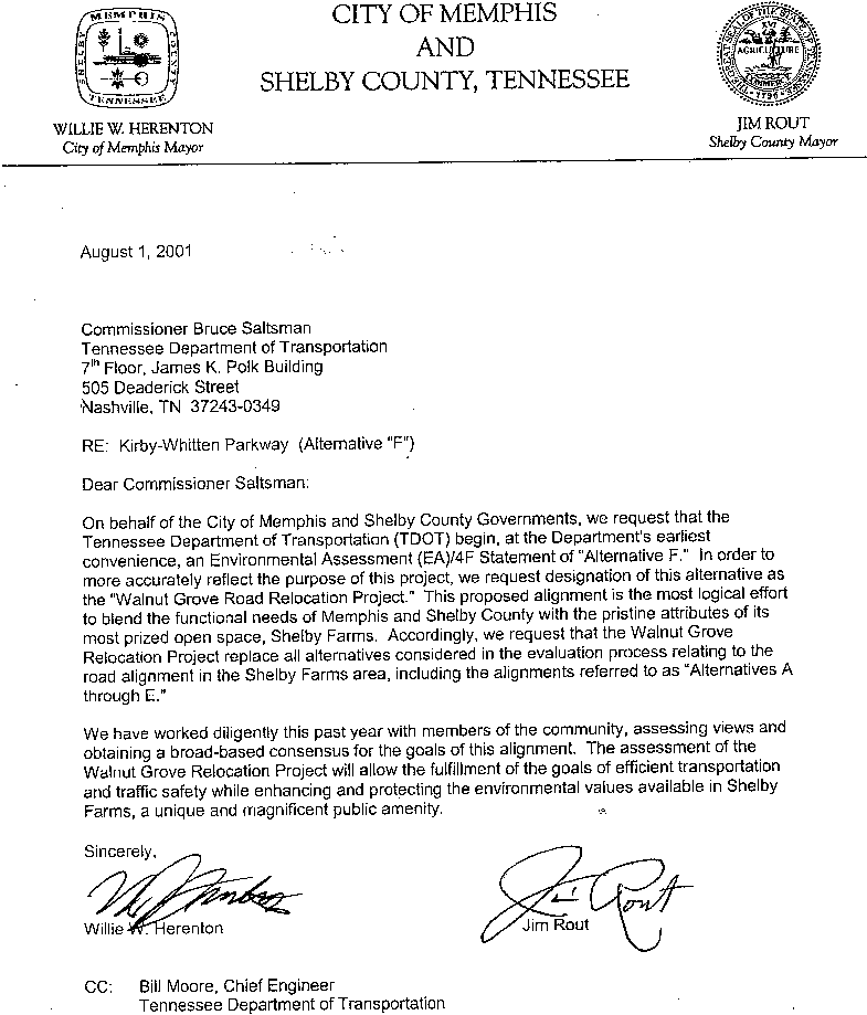
A joint announcement will be made by Shelby County and City of Memphis officials concerning their formal request that TDOT begin an Environmental Assessment (EA) 4F Statement of "Alternative F" and that this alternative be designated as the "Walnut Grove Road Relocation Project" to more accurately reflect the purpose and scope.
Both governments have formally requested that the Walnut Grove Relocation Project replace all alternatives considered in the environment evaluation process. And, both governments are requesting that TDOT and the Federal Highway Administration
(FHWA) consider six lanes, initially, with right of way for eight and that an eight-lane option be utilized if and when it is necessary to meet future traffic operating requirements.
For more information, contact Shelby County Public Works Director Ted Fox at (901) 545-4266 or Shelby County Engineer Michael Oakes at (901) 545-4332.
PUBLIC MEETING
KIRBY PARKWAY REEXAMINATION AND
WALNUT GROVE ROAD RELOCATION
September 24, 2001
6:00 to 8:00 PM
Shelby County and the City of Memphis would like to thank you for attending this public meeting tonight, and we invite you to look at the displays and ask questions of the government representatives and technical experts who are present this evening.
Purpose of the Meeting
The purpose of tonight's meeting is twofold. The first reason for the meeting is to present to you, the citizens of the city of Memphis and Shelby County, the findings of the recent study that re-examined the Kirby-Whitten Road alignment through Shelby Farms. That study was conducted under the auspices of the Tennessee Department of Transportation (TDOT). The environmental technical evaluation examined the preferred alternative (Alternative A) identified in the Final Environmental Impact Statement (FEIS) that was approved in 1991. The environmental technical study also examined four other alternatives (B, C, D, and E) for the Kirby-Whittten Road in the Shelby Farms area. During the public information meeting held on April 13, 2001, we promised that we would come back to the public with the results of that reexamination.
The second purpose of this meeting tonight is for Shelby County and the City of Memphis to make a joint announcement concerning their formal request to TDOT that an Environmental Assessment (EA) and a Section 4(f) Evaluation of Alternative F be prepared. To more accurately reflect its purpose and scope, we have requested that this alternative be designated as the 'Walnut Grove Road Relocation Project." Both governments have requested that Walnut Grove Road Relocation Project replace all alternatives previously considered in the environmental evaluation process relating to the new road alignment in the Shelby Farms area, including the alternatives referred to as Alternatives A through E. We are also requesting that TDOT and the Federal Highway Administration (FHWA) consider that the Walnut Grove Road Relocation project be six lanes, initially, with right-of-way for eight lanes ultimately, and that an eight-lane option be utilized if and when it is necessary to meet future traffic operating requirements.
This concept for relocation of Walnut Grove Road in the vicinity of Shelby Farms grew out of the 1975 Eckbo Plan for Shelby Farms. This proposed alignment appears to be the most logical effort to blend the functional needs of Memphis and Shelby County with the pristine attributes of Shelby Farms, one of the most prized open spaces in the area. We have worked diligently this past year with members of the community to assess views and obtain a broad base consensus for the goals of this alignment. We believe that the assessment of the Walnut Grove Road Relocation Project will allow the fulfillment of the goals of efficient transportation and traffic safety while enhancing and protecting the environmental values available in Shelby Farms, a unique and magnificent public amenity.
KIRBY PARKWAY
ENVIRONMENTAL TECHNICAL REPORT
EXECUTIVE SUMMARY
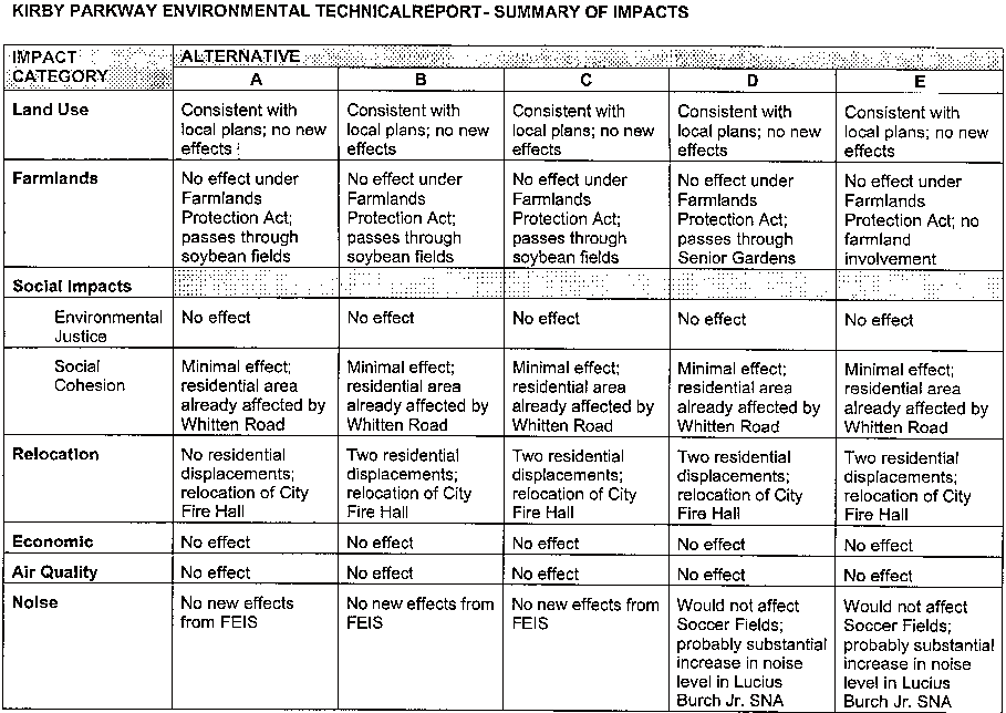
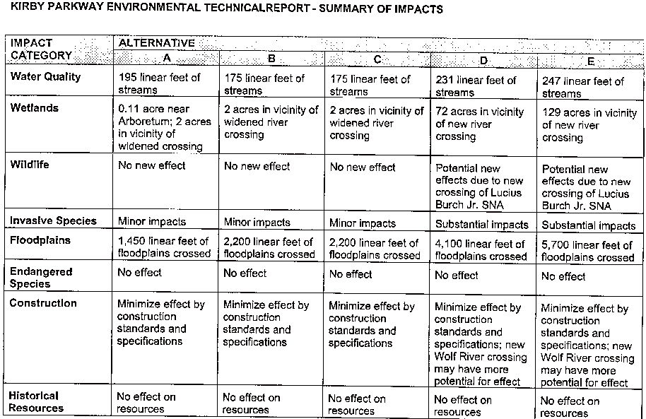
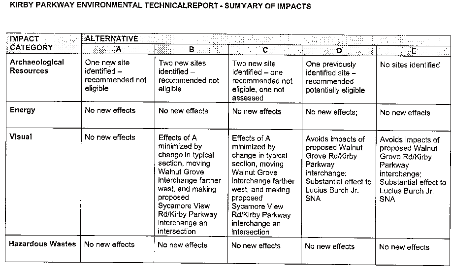
The Environmental Technical Report examined the existing environment of Shelby Farms and evaluated five alternative alignments to determine whether new significant impacts would occur as a result of changes in the project from what was described in the FEIS or whether there are new circumstances in the project area that would result in significant environmental impacts that were not addressed in the FEIS.
The alternatives examined in this study were:
Alternative A - Identified in the FEIS as the preferred alternative, this alternative consisted of the widening of Walnut Grove Road from the Humphreys Boulevard intersection to a new interchange west of the existing Farm Road/Walnut Grove Road intersection, a new road north across Shelby Farms to the intersection of Mullins Station Road and Whitten Road, and the widening of Whitten Road to Macon Road. This alternative also included an extension of Sycamore View Road
Alternative B - As a result of the comments received during the TDOT Design Public Hearing on November 17, 1994, and subsequent discussion between Shelby County officials and various citizens, Shelby County proposed a modification to Alternative A. In addition to revising the typical section of the proposed Kirby Parkway through Shelby Farm from six lanes to four lanes with a landscaped median, the alignment through Shelby Farms also was shifted to the west to increase the distance of the proposed roadway from Patriot's Lake, the Visitors Center, Plough Park and Chickasaw Lake.
Alternative C - The alignment of Alternative C is essentially the same as Alternative B, but the proposed intersection of Kirby Parkway and Sycamore View Road would be shifted west away from the Visitor Center complex.
Alternative D - This alternative was suggested by some members of the public in order to avoid the impacts associated with the proposed interchange at Walnut Grove and Kirby Parkway and construction of a major new roadway through the middle of Shelby Farms. It would follow North Humphreys Boulevard and have a new crossing of the Wolf River north of the existing Walnut Grove Road Bridge, before joining the alignment of Alternative B.
Alternative E - This alternative alignment would also follow North Humprheys Boulevard and
have a new crossing of the Wolf River north of the existing Walnut Grove Road Bridge. It would follow the TVA utility easement to the vicinity of existing Sycamore View Road.
The Environmental Technical Report examined the five alternatives' potential impacts on a variety of categories of social and natural environment resources. The accompanying table summarizes the results of the environmental technical examination. For each resource
category and each alternative alignment, the table indicates whether there are new or additional impacts from those identified in the FEIS.
WHAT IS INVOLVED IN AN ENVIRONMENTAL ASSESSMENT (EA)?
Shelby County and the City of Memphis have requested that TDOT begin an Environmental Assessment (EA) and Section 4(f) Evaluation for the Walnut Grove Road Relocation Project.
The National Environmental Policy Act (commonly referred to as NEPA) requires that any project funded with federal dollars undergo an evaluation of impact to the human environment before that project may be constructed. NEPA allows three levels of environmental analysis, based on the significance of the impacts of the proposed
project. The determination of significance requires consideration of both the context and intensity of the effects. Context refers to the setting of the action; for a highway project, significance would usually depend on the effect of the locale, rather than the world as a whole. Intensity refers to the severity of the effect.
The three environmental documentation options are
• Categorical Exclusion (CE) - appropriate when a project is not likely to have a significant impact on the human environment.
• Environmental Assessment (EA) - appropriate when the significance of the effects of the project is not clearly established.
• Environmental Impact Statement (EIS) - appropriate when the project would likely have a significant impact on the human environment.
When the significance of impacts is unclear, the appropriate level of documentation is an Environmental Assessment (EA). If at any time during the preparation of the EA, it is determined that an action is likely to have a significant impact, an EIS will be required and the analysis developed for the EA would be used in the preparation of the EIS.
Format
The format for an EA is generally as follows
• Purpose and Need for the project, including a description of the project.
• Alternatives Considered, including those removed from consideration.
• Environmental Impacts of the proposed project. Discusses social, economic and environmental impacts for each alternative, discusses mitigation measures,
addresses known and foreseeable public and agency concerns, discusses why impacts-are not significant.
• Comments and Coordination, which describes early agency and coordination efforts, summarizes key issues resulting from the coordination, and lists agencies.
• Section 4(f) Evaluation, a separate analysis that evaluates the effects of a transportation project on public parks, recreation area, or wildlife and waterfowl refuge, or any significant public or privately owned historic site.
• Appendices, which include technical studies and correspondence documenting coordination.
• Maps and Exhibits to help explain the material presented in the EA.
The types of environmental features that are addressed in an EA include, but are not limited to:
• Land Use • Wetlands & Floodplains
• Social • Rivers and streams
• Neighborhoods • Farmlands
• Economic • Soils and geology
• Visual • Hazardous materials
• Air quality • Historic and archaeological sites
• Noise • Parks and recreation areas
• Threatened & Endangered Species • Construction related impacts
Public Review and Comment
Throughout the EA process there will be opportunities for public input, including early coordination letters sent to local agencies and organizations. Although not required by NEPA, TDOT and the local officials may decide to hold a public informational meeting at the beginning of the study to request public input.
At the conclusion of the EA, TDOT will circulate the EA to state, local and federal agencies, and will publish a notice to the public that the EA is available for review and comment. A notice of availability of the EA will be sent to anyone who has formally requested notice. Copies of the EA will be available at TDOT and FWHA offices as well as in public places such as libraries.
A public hearing will be held in the local area to provide the opportunity for the public to view the plans for the project and to offer comments. At least 15 days advance notice will be give for the hearing. The public may provide written comments for at least 15 days after the hearing. The comments provided by the public as well as comments provided by government agencies will be used to determine the next step in the NEPA process.
Finding of No Significant Impact (FONSI)
At the conclusion of the EA and following the public comment period, a determination is made whether to prepare a Finding of No Significant Impact (FONSI) or and Environmental Impact Statement (EIS). For highway projects, the Federal Highway Administration (FHWA) makes the final call on significance after reviewing all the study results.
If FHWA determines that the project will have no significant impact on the environment, a FONSI document will be prepared. The FONSI briefly presents why the project does not have a significant impact. It may reference a revised EA, or the FONSI may be in the format of the EA. The FONSI will address substantive issues raised during the public involvement and agency coordination process, and will reflect changes in the project as a result of the coordination process.
How Long Will It Take to Prepare the EA?
The EA for the Walnut Grove Road Relocation Project is expected to take 12 to 18 months to complete.
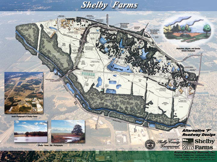
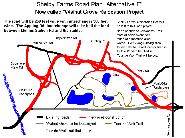
Artist conception of Walnut Grove Relocation Project.
A large version of this map is on display in the Shelby Farms Visitor Center.
On March 26, 2002, the Tennessee Department of Transportation held a public meeting at the Agricenter to show the proposed design and route of Walnut Grove relocated. The display consisted of aerial photographs of the park area with an overlay of the road design.
This writer's impression is that it is a VERY WIDE road. The average right of way will be 250 feet. Interchanges will be 500 feet wide. The design includes 6 traffic lanes and a 72 foot median. Much of the north section of Shelby Farms will be taken for this project.
Anyone who uses the north side of the park will recognize the amenities that will be lost Once the road enters the north edge of the park everything on that side will be gone. If you use the Chickasaw Lake paved trail, imagine road from the pine forest all the way to existing Mullins Station Rd.
The north events field will be all but gone. The Appling Rd interchange will be 500 feet wide. This will take all the land from existing Mullins Station Rd to half way to the stable. The north equestrian corridor will be taken, as well as much of the equestrian events field.
If you run your dog in the gate 11 and 12 area, this will be gone. Pattern lake may be reduced in size. Indian lake will be reduced or filled in completely. To the south, Willow Pond will be filled in. I was told this by one of the TDOT representatives at the meeting.
Anyone who mountain bikes, hikes, runs, walks, or rides a horse recognizes the east section of the Tour-de-Wolf Trail is one of the most scenic areas of the park. Some of this will be lost and the rest cut off by this road. The engineer's solution is to build a 10'X10" pedestrian underpass. Two 10 foot by 60 foot long tunnels to get from one side of the road to the other.
The north side of Shelby Farms contains some of the most scenic areas of the park. Much of this will be lost, and the remaining north area will be impacted by the sight, sound, and smell of a road the size of a major interstate highway. In return the park gets back the existing Walnut Grove Road right of way.
The proponents of Alternate F are asking us to trade away the rolling hills, forested areas, lakes, and popular recreational areas of Shelby Farms and in return get an old road right of way that is of less scenic value. Not a good trade.
After seeing this plan, many people think a better alternative is to leave Walnut Grove where it is. Widen it, improve it, but leave it there. The park amenities have been built around Walnut Grove and would not be destroyed by leaving it in the same place.
Highway engineers insist a north-south connector road is necessary through the park. When the I-40 / I-240 interchange rework is complete this may not be the case. However, a north-south road could be built through the west edge of the park, connect to Sycamore View and Kirby-Whitten and stop there. This would save the parts of Shelby Farms many people actually use.
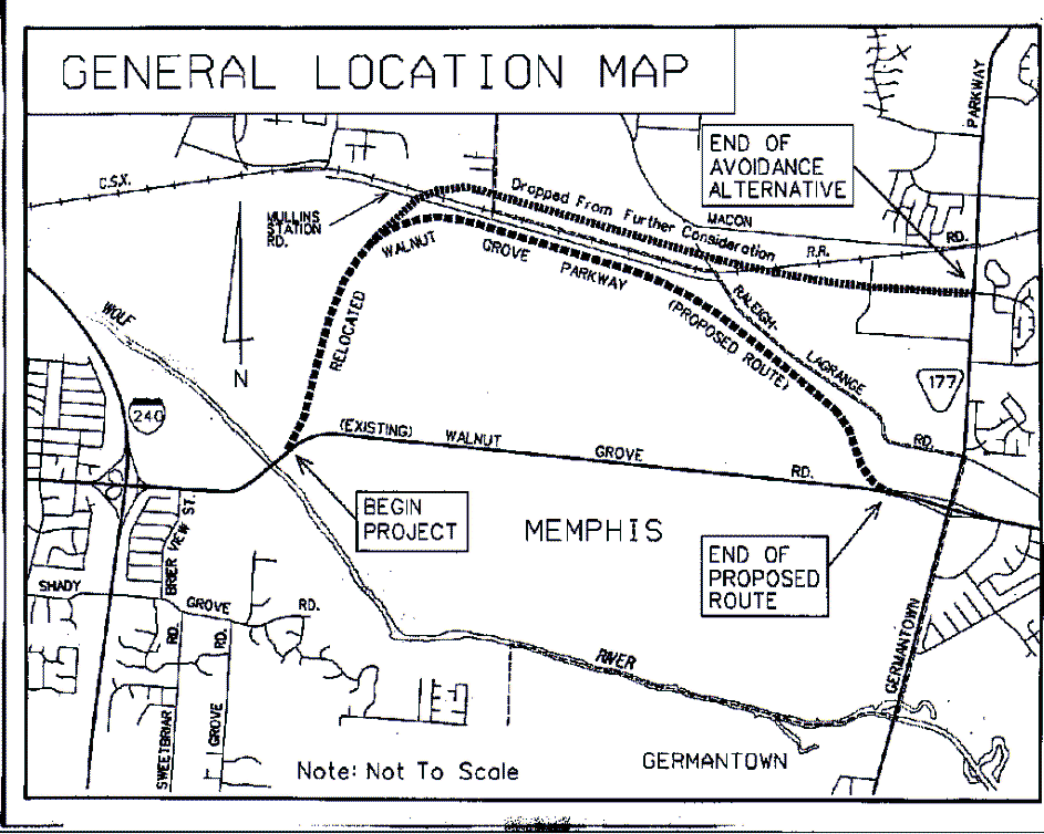
Copied below is a map showing the approximate intended route and a the hand out material from the meeting. If you agree that this road plan leaves a lot to be desired, make your opinion known to the officials in charge of this project. Mailing and e-mail addresses are included and new ones will be added as discovered.

PUBLIC MEETING HANDOUT
WALNUT GROVE PARKWAY RELOCATION
FROM HUMPHREYS BOULEVARD
TO SR-177 (GERMANTOWN PARKWAY)
SHELBY COUNTY
The Tennessee Department of Transportation welcomes you to tonight's informal "Open House" public meeting. The purpose of this meeting is to give the public an opportunity to review and comment on the Department's proposal to relocate Walnut Grove Parkway within stated termini. Please be aware that this plan is preliminary in nature and may change with the input of public opinion.
As depicted on the General Location Map, this project has two viable routes, "proposed route" and "avoidance alternative ". Both routes typically have cross- sections of three (3) 12-foot traffic lanes in each direction, 12-foot shoulders, with ditches, and a 72-foot depressed, grassed median, all within a minimum 250-foot right-of-way. Auxiliary lanes connecting ramp movements are provided throughout most of both corridors. Both routes begin at the Wolf River Bridge. The 4.5-mile "proposed route" remains to the south of the railroad tracks and terminates at the existing Walnut Grove Road @ Germantown Parkway single-point (urban) interchange. The 4.2-mile "avoidance alternative" crosses the railroad tracks twice with grade-separations at each location and ties in the Germantown Parkway at Fischer Steel Road/Walnut Run Road. The "avoidance alternative" was dropped from further consideration because it did not meet the need and purpose of this study.
Comments and suggestions received at this meeting will help further refine all aspects of project alignment and design. Comment sheets are provided and may be turned in at the meeting. Comment sheets and written statements may be mailed to the address below, but they must be received within ten days to be included in the project file for this meeting:
Project Comments
Tennessee Department of Transportation
Suite 700, James K. Polk Building
505 Deaderick Street
Nashville, Tennessee 37243-0332
We appreciate your interest and urge everyone to express his or her views on any aspect of this project.
Walnut Grove Parkway Relocation
Frequently Asked Questions
The intent of tonight's meeting is to provide preliminary information to the public about the current proposal and invite ongoing public comment and participation in the development of this project. It should be noted that this project is in the early stages of development and effective public involvement is necessary.
2. What is the purpose of this project?
The purpose of this project is twofold. The intent is to improve the transportation network in eastern Shelby County, and enhance the scenic and recreational value of Shelby Farms by removing the existing Walnut Grove Road from the middle of the Farms and relocating it to the northern periphery.
The project is expected to improve mobility and reduce traffic congestion along existing routes in east Memphis. The project will accommodate continuous north-south traffic between Humphreys Boulevard and Whitten Road (proposed Kirby Parkway north of Shelby Farms). It will also continue to serve the east-west traffic movement which is consistent with Memphis Long-Range Transportation Plan.
3. Why did the purpose and need of the original project change?
The purpose and need of the original project changed as a result of the community working together to reach a consensus on an alignment that more closely supported the park and its
sensitive environment as well as meeting future traffic demands.
4. What is the Shelby Farms Board role in the process
The Shelby Farms Governance Authority will play a prominent role in providing appropriate input into the process when required.
5. How does this project affect Shelby Farms?
Preliminary studies indicate that the proposal may have varied effects on Shelby Farms. The advantages to Shelby Farms are consolidation of land, better access between north and south Shelby Farms by removal of the bisecting barrier created by the existing Walnut Grove Road, and improving the scenic vistas from the middle of Shelby Farms. The degree of impact and mitigation measures will be assessed as further project development occurs.
6. Who is endorsing this project?
Shelby County and the City of Memphis endorse this project as a way to improve the transportation network in eastern Shelby County and enhance Shelby Farms with the relocation of Walnut Grove Road to the northern periphery, thereby allowing a consolidation of the open spaces within Shelby Farms by removing the existing Walnut Grove Road. This proposal for the relocation of Walnut Grove Road is the culmination of extensive discussions in Memphis and Shelby County among local officials and citizens regarding the future of Shelby Farms recreational areas. This proposal is envisioned as a "Parkway" type facility, which is consistent with the master plan for Shelby Farms.
7. Was an avoidance alternative for this project evaluated?
An avoidance alternative was carefully evaluated and found not to meet the purpose and need for this project. Based on this finding, it was dropped from final consideration.
8. What are some of the features being considered in this project that enhance Shelby Farms?
It is the desire of the City and County to provide a roadway that "fits-in" with the context of the area and is compatible with the park-like setting. Bicycle lanes, landscaped median, and earth berm are being considered.
9. Is the CSX Railroad line is being abandoned, can the proposed roadway utilize that land?
CSX was denied abandonment of rail line; therefore railroad right-of-way can not be used in this proposal.
10. What is the schedule for this project?
The Tennessee Department of Transportation's commitment to Shelby County is to finalize this Advance Planning Report (APR). Based on the results of the APR any future project funding must be consistent with the Memphis Transportation Improvement Program based on transportation priorities identified through the transportation planning process of the Memphis Area Metropolitan Planning Organization (MPO).
11. Have you already made a decision on this project?
No. This project is in the very early stages of development. Public input is very important to the decision-making process to further develop this project.
12. Will there be additional opportunities for public comment and, if so, how many and when?
Yes, additional public meetings/hearings will be held during, the Environmental Impact Statement (EIS) as well as design phase. While the exact number and dates have not been determined at this time, there will be a number scheduled throughout the process over a 2-5 year period.
13. What is the estimated cost of this project?
Cost estimates will be developed after decisions reached on type facility and enhancements to be designed.
14. Where will the money come from to build Walnut Grove Road Relocated?
The majority of the funding will be provided by the Federal Highway Administration. Moneys that have been allocated for the widening of current Walnut Grove Road and Mullins Station Road will also be used to support construction costs.
15. How much of the funding will come from local sources?
Approximately 20% of the project will come from local sources.
16. Who will ultimately make the decisions?
Elected officials will make the final decisions.
17. What is the timetable for construction of the road?
See attached page with project milestones.
18. Where can I go for answers to future questions?
Shelby County Public Works (545-4266/4565) will provide the lead role in terms of being a single point of contact for questions concerning the proposed project.
(Walnut Grove Parkway Relocated)
March 26, 2002
January 2002 ............................ Draft Advanced Planning Report for Comments
February 2002 .......................... Draft Advanced Planning Report back to Consultants
June 2002 .................................. Finalize Advanced Planning Report Document
September 2003 ....................... Final EIS Approved (18 Months)
June 2005 .................................. Design/Survey (21 Months)
June 2006 .................................. Appraisal/R.O.W. Acquisition (12 Months)
July 2006-January 2007 .............. Let Construction Contract
Note:
The above dates reflect the earliest possible completion milestones.
The Shelby Farms Board hereby adopts the following resolution, for submission to the Mayors of Shelby County and the City of Memphis:
It is HEREBY RESOLVED that, WHEREAS.
The Shelby Farms Board has by Shelby County ordinance been charged with the responsibility of supervising Shelby Farms park;
A relocation of Walnut Grove Road being presently considered by the Tennessee Department of Transportation (TDOT) routes the road in general conformity with the routing proposed decades ago in the plan for Shelby Farms known as the Eckbo plan;
This Board agrees in general on the need to service traffic needs of the community on the general route, of the road, subject to a more detailed agreement on the road's route and design;
Our community has an unfortunate history of major roads through the community and parks being delayed or blocked, with major traffic disruption, because of the unwillingness of designers to consider all aspects of and alternatives to their proposals, and this should be avoided with the proposed Walnut Grove relocation;
The planning group that began in December, 2001 to initiate the design of the road did not include any member of this Board,
The minutes of the meetings of that group indicate that the intention was to create a parkway, however latest design we have seen contemplates a 60 mile per hour speed limit and a 250 foot right of way, leading toward a conventional interstate expressway rather than a parkway design;
Such a design will lead to unnecessary destruction of parkland, create environmental issues for the park including excessive noise and air emissions, complicate rather than enhance the free flow of traffic on Walnut Grove and other major traffic arteries, and further contribute to urban sprawl - all of which, in addition to being undesirable for obvious reasons, may also present legal, political, and practical issues which may greatly delay or prevent any resolution of the matter;
THEREFORE, the Shelby Farms Board recommends to the Mayors of Shelby County and the City of Memphis:
That the Mayors and their Administrations immediately go on record with TDOT expressing their intention that the design speed for the road not exceed 45 miles an hour, as is the case with all similar local (i.e. non-interstate) roads, including for example Humphreys Boulevard;
That they request a parkway design with no more intense traffic specifications than similar local roads, and with the height of no structure in the design exceeding grade level,,
That the need for a 250 foot right of way be reexamined, especially in the wooded area in the eastern portion of the road, and that every attempt be made to use a significantly narrower right of way, not to exceed the width of Humphreys Boulevard;
That, since the CSX rail line on the north side of the park is no longer needed by the railroad, and since expensive repairs would be needed on the bridge over the Wolf River in order to render the rail line usable, they aggressively pursue acquisition of the right of way of that rail line and its use for the relocated Walnut Grove, thereby preventing a 100 foot intrusion by the road into parkland;
That any outparcels of Shelby Farms outside the new road continue to be used as parkland;
That any design of the road include segregated, safe pedestrian and bike access to the park at all intersections.
Adopted by the Shelby Farms Board this ____day of _______, 2002,
SHELBY FARMS BOARD
_______________________
By Ron Terry, Chairman
As reported in the Commercial Appeal, Memphis Mayor Willie Herenton and Shelby County Mayor A. C. Wharton Jr. announced Alternative F was dropped in favor of taking a second look at Alternative B.
When Alternative F was announced it was hailed as the solution to the road issue in Shelby Farms. Alternative F was announced as a "parkway" design. The public envisioned something akin to North Parkway. The engineer's design more resembled Nonconnah Parkway.
The 8 lane 60 mile/hour design with it's huge interchanges recieved stiff opposition due to it's 250 to 500 foot right of way. The design would have destroyed many highly used park ammenities.
Alternative B is a modification of the original TDOT design. This design does place an interchange near the western edge of Patriot Lake. The road would then go north to a junction of Sycamore View and Whitten Roads. The remainder of the park land to the east would be untouched.
This decision removes the threat to the Tour-de-Wolf trail as well as the dog area, equestrian area, several lakes, and other recreational areas along the north edge of the park.
