

Information About the Shelby Farms Parkway Advisory Team January and February 2006 Meetings
Our collection of past Shelby Farms road information is available in the archive pages.
Click here to go to the road archive>
Information about the Walnut Grove and Humphries Blvd. project is available at www.walnutgroveroad.com
The Shelby Farms Parkway Advisory Team met in January and February to refine the designs selected in previous meetings. In January the team discussed the input resulting from the two alternatives presented at the public meeting. In addition, several refinements were shown by Palmer Engineering.
The February meeting was held to narrow the selection to one design concept. After a lot of discussion, the team decided on a final concept. The design includes:
•
40 mph design speed
• 4 lanes (12-foot lane width)
• Independent roadway concept
• Curvilinear alignment
• At-grade intersections at Sycamore View and at Mullins Station
• Grade separation at Walnut Grove
Nobody on the team achieved everything they desired. We did achieve a road concept that can complement the park and will not be overwhelming. Many team members are concerned about connectivity within the park. We stressed there be connections north-south-east-west to maintain access to all sections of Shelby Farms. The final design of these connections will be included in the park master plan. That process is under way now. The team also recommended continuing to follow the design through engineering phases to be sure the team's design intent be followed.
Suggested Design for Shelby Farms Parkway

Palmer Engineering modified the design of the south side of interchange to create a "no impact" design. Modifying the loop and reducing the ramp speed from 25 mph to 20 mph accomplished this design. The redesigned interchange has no elements on the landfill and does not move Walnut Grove any further north than the original design. The no impact design is shown below.

On July 31, the Shelby Farms Parkway Advisory Team met to see the results of the requested study about moving the Walnut Grove interchange further south. This would require building on the existing landfill or mitigating the landfill. The study was done by Stantec Consulting, which has engineered landfill sites since 1954. Stantec is a recognized leader in this field.
Stantec outlined three methods of dealing with the landfill and construction. The first way to accomplish this is to build on the landfill with strengthening and bridging elements in the design. This option was proved not feasible due to the instability in this landfill.
The second construction option is to build foundations through the landfill to solid ground underneath. The problem with this option is it would likely lead to leeching landfill byproducts into the sand aquifer which is protected by a thin clay cap. This could endanger the Memphis water supply and was rejected for that reason.
The last option is to remove the waste and relocate it to another site. Then fill the excavated area with engineered fill. This would create a solid base suitable for construction. This was chosen as the only possible option.
The original interchange design (shown below) had some elements south of Walnut Grove Road. It was believed the landfill boundary was south of the road. The study has shown the landfill extends all the way to the south embankment of Walnut Grove Road.

The second option presented was the original interchange design with the landfill mitigated to accommodate the footprint. Relocating the waste and filling the site for this option is estimated at $6.6M. See the option 1 design below.

The third option is to remove enough waste to Walnut Grove in its present location and place the south side of the interchange in the landfill area. The estimate for this option is $33.5M. See option 2 below.

This meeting was intended to be informational but the team decided to make a recommendation just to be on record. Option 1 was discarded because it does not move Walnut Grove any further south, which was the point of this study. The six million-dollar expenditure would only achieve keeping the ramp at 25-mph speed. Option 2 was discarded due to the cost. The road project itself is estimated to cost between $15-$20M. This option at $33.5M could cost twice the cost of the road project. The cost benefit ratio does not support option 2. The team decided to recommend the "no impact" option to keep the overall project cost within reason.
A secondary discussion was about how the road project and the newly approved Shelby Farms Master Plan will interact. The master plan has a number of elements included for bike and pedestrian traffic to be able to move around the park unimpeded by road crossings. In our sign off meeting Februry 2006, the advisory team insisted that there be bike and pedestrian connections north-south and east-west in the road corridor. City Engineer Wain Gaskins said that several connections that are in the team's study area would be included in the design and construction of Shelby Farms Parkway.
The design team intends to follow the progress of this project to ensure the team's recommendations are being followed. If any problems develop they will come to my attention and will be reported on our MSTA web site.
Brad
A summary of the Shelby Farms Parkway Advisory Team meeting on July 31, 2008, about the Stantec landfill study.
June 27, 2012, Shelby Farms Parkway CSS Team Meeting
On June 27, 2012, I attended a Shelby Farms Parkway CSS Team meeting. This meeting was to review the preliminary construction plans for this roadway. I am pleased to report the road design was modified to include several new bicycle and pedestrian connections. These are to accommodate the new connector to the Shelby Farms Greenline and the connector to the Wolf River Bridge. The modifications also include moving the parallel bike paths that were on the road shoulders to separated paths.
Farm Road will be cut into several segments. The north segment will be a dead end to serve the government buildings and Humane Society area. The segment of farm road that will intersect the new parkway will have a tunnel and will be converted into the bicycle and pedestrian connection between the greenline and the rest of the park. Only park maintenance vehicles will use this connection. There will not be public vehicle access.
The center section of Farm Road will become a park entrance from the new north-south parkway.
Another tunnel will be constructed under the parkway in the field north of existing Walnut Grove to accommodate the east-west park bicycle and pedestrian traffic. This will be the location of the future "park circle" trail and will connect to the bike paths that parallel each side of the parkway.
To maintain the connection between Patriot Lake and the Wolf River Bridge a semi-depressed tunnel is added to the design near the existing Farm Road crossing. Walnut Grove will be raised above existing grade to get the rest of the needed clearance.
In the future a park entrance will be added at the east end of the south Patriot Lake parking lot across from the Catch'em Lake. This would be a simple right in right out connection. The park master plan calls for a land bridge across Walnut Grove more eastward. A small park sized interchange may be added to this bridge to give full access to Shelby Farms from Walnut Grove.
The soon to be constructed SF Greenline east from Farm Road will intersect with Whitten Rd. When the new parkway is built the greenline will be rerouted to the signalized intersection. The road will be depressed where it crosses the existing rail bed. This will make it possible to bridge the greenline over Whtten Road to eliminate the people/vehicle interaction at this location.
During the meeting I emphasized the importance of maintaining vehicle access to the old soccer field area. This is required to allow vehicles to get to the trail head for maintenance, access to the canoe ramp, and access to the BMX track. I was assured that this access will be maintained but the turn off from Walnut Grove may be in a different location.
An illustration is below that shows these facilities. There will also be a public meeting on the design scheduled in the future when the plans are more complete.

I attended the TDOT public meeting about the Shelby Farms Parkway (Kirby-Whitten Parkway) proposed plan. Representatives of TDOT, Shelby County, City of Memphis, and Shelby Farms made a short presentation about the road plan. After the presentation there was a question and answer session. The meeting was well attended and many diverse opinions about the plan were expressed.
Members of the public asked questions and made comments. These ranged from get busy and build the road, examine other alternatives, upgrade Farm Road, to build nothing.
Shelby Farms Park has yet to sign off on the project because some of their requirements are not met. A major point is that Shelby Farms Park and the advisory team recommended that large trucks not be allowed on the parkway. Federal law requires that if federal money goes to the project trucks must be allowed. City and county government officials are working with the Tennessee congressional delegation to pass an exemption for this road. Near the end of the meeting it was made clear that if Shelby Farms Park does not sign off the project will not move forward.
From the Shelby Farms Park web site>
The City of Memphis, TDOT, and Shelby County Government have requested that that we, SFPC, agree that the plans for the Parkway incorporate all possible planning to minimize harm to Shelby Farms Park (de minimis determination). In order for us to make this decision, we requested guarantees that certain conditions will be met.
We asked to be guaranteed that:
- The Parkway design makes it easy for visitors to get to and around the Park
- That Walnut Grove won't be widened and that its speed limits will be reduced, and that Sycamore View will not be extended through the Park
- That the Parkway prioritizes bike, equestrian and pedestrian access and connectivity to the Shelby Farms Greenline and Wolf River Greenway
- That the Parkway enhances bike and pedestrian access to and from neighborhoods around the Park
- That the Parkway enhances pedestrian and vehicular connectivity between the north, south, east and west areas of the Park
- That the Parkway doesn't harm our floodplain or aquifer and honors our natural environment
- That the Parkway design complements the bold and aspirational vision for Shelby Farms Park
- That the Parkway has underground utilities and no lighting
- That tractor-trailers won't be allowed on the Parkway
- That citizens will be provided an easy to understand 3-D model of the Parkway in relation to the Park at a public meeting in the fall and will have full opportunity to comment
The bicycle and pedestrian access elements added to the project remain in the design. These features maintain all current connections to the park. Safety is improved through the use of grade separated crossings that eliminate encounters with motor vehicles. An additional road extension will be built south of Walnut Grove for access to the BMX track, boat ramp, and Wolf River Trails. That will use the same entrance as Catch'em Lake.
The soon to be started Greenline expansion will be built before this road project. The project includes a signalized at grade intersection at Mullins Station. A bike path is included to take Greenline users to the safer crossing. The road will be depressed at this location to facilitate a bridge for the Greenline. City and county governments are working on separate funding for this bridge.
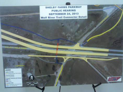
The meeting handout and a comment sheet are available below for download. There are also pictures of the illustrations presented that show the bike/pedestrian facilities.
Brad C.


Walnut Grove / Farm Road area.
The comment period ended Oct. 15, 2013
Connection to Walnut Grove bridge bike lane.
S/F Parkway / Mullins Station signalized intersection.
Bridge over old Farm Rd. for Greenline connector.